To measure distance in Google Maps on a computer, right-click your starting point, select Measure distance, then click the map to add points; the total appears at the bottom in miles and kilometres.
This guide covers the computer, Android and iPhone steps, route distance by car or on foot, measuring area with Google Earth, changing units, and fixes when the option is missing.
How To Measure Distance In Google Maps On A Computer
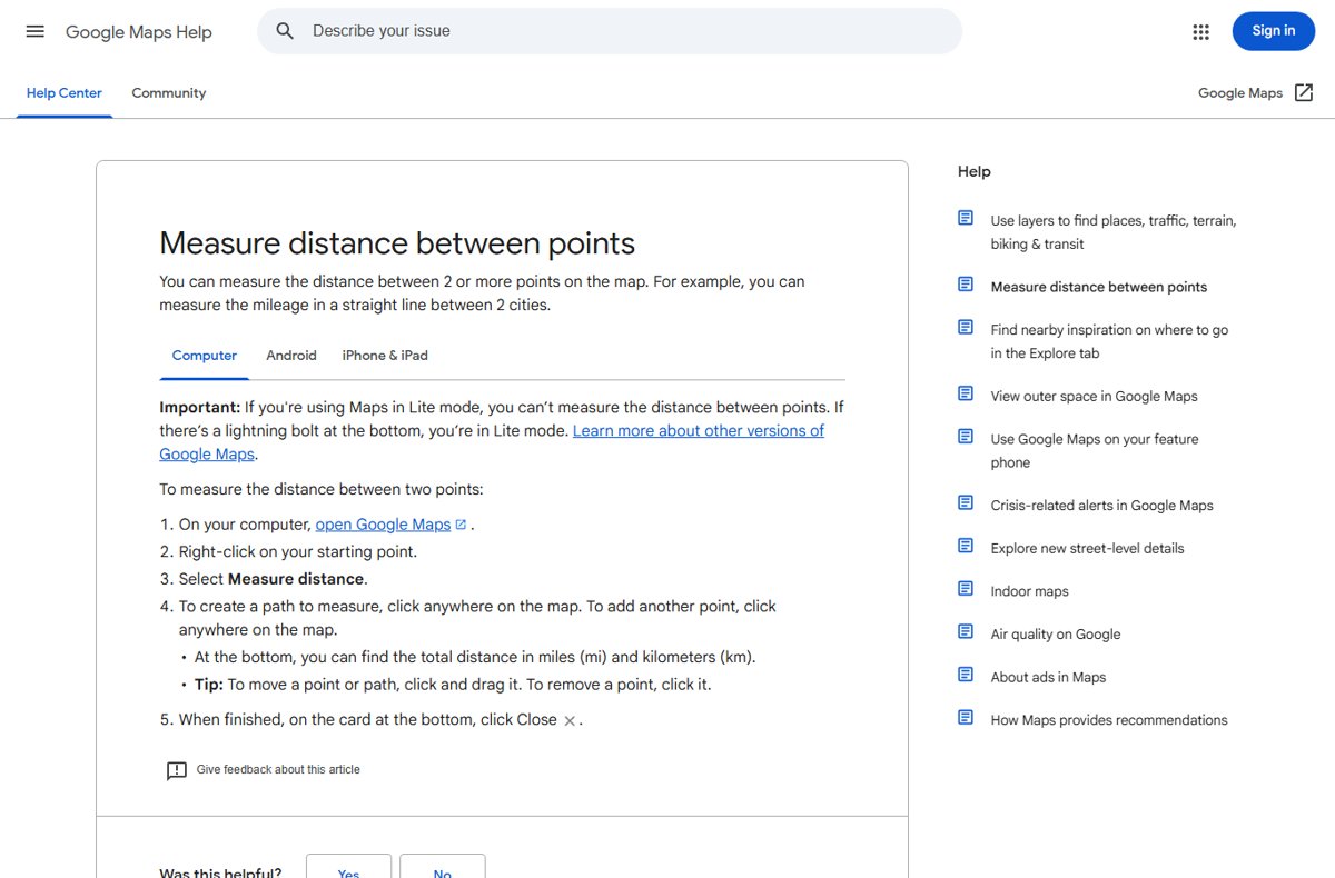
This works in Google Maps in any desktop browser, as long as Maps is not running in Lite mode.
- Open Google Maps on your computer.
- Right-click your starting point.
- Select Measure distance.
- Click anywhere on the map to set the next point. Keep clicking to add more points along a path.
- Read the total distance at the bottom, shown in miles (mi) and kilometres (km).
- To move a point or the path, click and drag it; to remove a point, click it.
- When finished, select Close on the card at the bottom.
What “Measure Distance” Means In Google Maps
Measure distance gives the straight-line distance between points you place, often called the air or aerial distance. It does not follow roads. For travel distance, use directions instead.
| You want | Use | What you get |
|---|---|---|
| Straight-line (air) distance between two places | Measure distance | Distance as the crow flies |
| Length of a path you trace, such as a fence or trail | Measure distance with several points | Total of every segment |
| Road or walking distance | Directions | Route length and travel time |
| Area of a field or plot | Google Earth measure tool | Area of a closed shape |
| Height or elevation along a route | Google Earth Pro elevation profile | Elevation and distance chart |
How To Measure Distance In Google Maps On Android
- Open the Google Maps app on your Android phone or tablet.
- Touch and hold anywhere on the map that is not a place's name or icon. A red pin appears.
- Select Measure distance.
- Move the map so the black circle sits on the next point you want.
- Tap Add point at the bottom right. Repeat for more points.
- Read the total at the bottom in miles and kilometres.
- Tap Undo to remove the last point, or More > Clear to start over. Tap the back arrow when finished.
How To Measure Distance In Google Maps On iPhone And iPad
The iPhone and iPad steps match Android: you move the map under a fixed black circle rather than tapping points.
- Open the Google Maps app on your iPhone or iPad.
- Touch and hold an empty spot on the map until a red pin appears.
- Select Measure distance.
- Drag the map so the black circle is on your next point.
- Tap Add point at the bottom right, and repeat as needed.
- Read the total at the bottom; tap Undo or More > Clear to fix mistakes, then tap the back arrow.
How To Measure Driving, Walking, Cycling, Or Transit Distance
Directions measure the distance along real roads and paths. Each route shows its length and estimated time.
- Open Google Maps and select Directions.
- Enter the starting point and destination, or click points on the map.
- Choose Driving, Transit, Walking or Cycle.
- Compare the routes: the best is blue and the others grey, each with its distance and time.
- To measure a trip with stops, select Add destination. You can add up to 9 stops, including the final destination, for every mode except transit and flights.
How To Measure Area In Google Maps
Google Maps help documents distance only. To measure an area, use the free Google Earth on the web, which closes a shape and reports its area.
- Open Google Earth in your browser and search for the place.
- Select Measure on the left. Earth switches to a top-down view.
- Click the map to set points around the edge of the area.
- Click your first point again to close the shape.
- Read the area on the right. Select Undo to remove a point, or drag points to adjust the shape.
Google Earth Pro on desktop offers more shapes under Tools > Ruler, including polygons, circles and 3D polygons for building height and area.
How To Change Distance Units In Google Maps
| Device | Steps | Options |
|---|---|---|
| Computer | Sign in to Google Maps and click the scale at the bottom right | Each click switches between miles and kilometres |
| Android | Tap your profile picture > Settings > Navigation > Distance units | Automatic, Kilometers or Miles |
| iPhone and iPad | Tap your profile picture > Settings > Navigation > Distance units | Automatic, Kilometers or Miles |
| Google Earth (web) | After measuring, open the unit drop-down next to the result | Pick any listed unit |
Measure distance always shows both miles and kilometres, so the unit setting matters most for directions and navigation.
Practical Examples Of Measuring Distance
| Task | How to do it |
|---|---|
| Flight distance between two cities | Measure distance with one point in each city |
| Length of a running loop | Measure distance, add points along the path and finish at the start |
| Fence length around a garden | Measure distance with a point at each corner |
| Commute length by car | Directions with Driving selected |
| Size of a field or lot | Google Earth Measure, closing the shape |
| Elevation gain on a hike | Google Earth Pro path, then Edit > Show Elevation Profile |
How Accurate Is Google Maps Distance Measurement?
Measure distance is a flat, straight-line figure between the points you place. Its accuracy depends mostly on how carefully you place those points.
| Factor | Effect on the result |
|---|---|
| Straight lines only | A curving road or trail measures shorter unless you add points along the bends |
| Zoom level | Points placed at a low zoom can land metres away from the real spot |
| Elevation | Google Earth states its measurements do not account for changes in elevation; the map distance is flat too |
| 3D terrain and buildings | Google Earth warns measurements may not be fully accurate in 3D views; measure from a top-down view |
Troubleshooting: If Measure Distance Is Missing Or Not Working
Measure distance is missing from the right-click menu on a computer
Google Maps is running in Lite mode, which cannot measure distance. A lightning bolt at the bottom of the map marks Lite mode.
- Look for the lightning bolt at the bottom of the map.
- Update your browser to the current version and reload Google Maps.
- Try another supported desktop browser if Lite mode persists.
Measure distance does not appear on Android or iPhone
The touch-and-hold landed on a place name or icon, which opens the place instead.
- Touch and hold an empty area of the map, away from labels and icons.
- Wait for the red pin, then open its card and select Measure distance.
- Update the Google Maps app if the option still does not appear.
The measured distance looks too short
Measure distance draws straight lines between points.
- Add more points along each bend of the road or trail.
- Zoom in before placing points.
- For road distance, use Directions instead.
Google Maps Distance Measurement Tips
| Tip | Why |
|---|---|
| Zoom in before each click | Points land closer to the real spot |
| Use satellite view for fields and buildings | Edges are easier to see than on the map view |
| Drag the path instead of starting again | Click and drag moves a point or the whole path |
| Use Google Earth for area or elevation | Google Maps only measures distance |
| Turn on the scale bar on mobile | Settings > App & display > Show scale on map helps judge short distances |
Frequently Asked Questions
Can I measure distance in Google Maps?
Yes. On a computer, right-click a point and select Measure distance. On Android or iPhone, touch and hold an empty spot, select Measure distance and use Add point. The total shows in miles and kilometres.
How do I measure distance in Google Maps on a PC?
Open Google Maps in your browser, right-click the starting point and select Measure distance. Click the map to add points; the total appears at the bottom. Select Close on the bottom card when finished.
How do I measure aerial or air distance in Google Maps?
Use Measure distance. It draws a straight line between the points you place, which is the air distance. Put one point at each location and read the total at the bottom.
How do I measure distance in Google Earth?
Open Google Earth, select Measure on the left and click the map to set points. Double-click the last point or select Done to finish; the length appears on the right. Close the shape to get an area.
How do I measure distance in Google Earth Pro?
In Google Earth Pro, select Tools > Ruler, pick Mouse Navigation and the tab for the shape you want, then click a start and end point. The result appears in the Ruler window, where Save stores it under Places.
Can I measure distance on Google Earth on a phone?
Yes. Google Earth's measure tool is available on Android, iPhone and iPad as well as the web, with the same points-based approach and an area result when you close a shape.
Does Google Maps measure distance by road?
Measure distance does not follow roads. Use Directions and choose Driving, Walking, Cycle or Transit to get the distance along the actual route, with its estimated travel time.